
The Myanmar Cave Documentation Project was initiated by Joerg Dreybrodt in 2009. I got involved along with Imogen Furlong, Pete Talling and Phil Rowsell in 2010, before returning the following 4 winters. During this time we have seen a lot of political change and an increase in tourism, but throughout the period the people of Myanmar have always been incredibly welcoming.
2010: A four person expedition to the Taunggyi and Hopon region of the Southern Shan State, we first visited this area due to an article in an in flight magazine about Htam Sam and large and well decorated temple cave in the region. In total we mapped 2.9km of passage in 6 separate caves as well as identifying many more. Download: ShanPlateau_Expedition_Report_2010_Issue2_with surveys_low res
2011: A six person team returned first to the Taunggyi and Hopon area and notably extended Hopon Spring Cave to 1655m length. The expedition then moved to the Northern Shan State, carrying out initial reconnaissance in the areas of Kutcai and Lashio. In total the expedition mapped 4.6km of cave passage. Download: Shan Plateau Expedition 2011 Final Report.
2012: The expedition was mainly focused on Ywangan Township near the border of the Southern Shan State and Mandalay Division. It explored the significant river cave Kyauk Khaung (Stone Cave) to 2.3 km in length, before attempting further exploration of a further river cave previously identified near Lashio. However this latter objective was thwarted by local political instability. In total the Shan Plateau Expedition 2012 mapped 3.3 km of cave at 6 sites and recorded a further 14 sites of speleological interest. Download: Shan Plateau Expedition 2012 edited
2013: Returning to Kyauk Khaung, the expedition extended this major cave from 2.3 km to 4.8km in length. In addition the 2013 expedition collected, and preserved, samples of the first cave-adapted fish reported from Myanmar. Download: Shan Plateau Expedition 2012-13 final report
2014: The expedition extended the exploration in Ywangan Township to the north of Kyauk Khaung into the area known locally as the “Dragon Lake”, a large doline that seasonally fills to become a lake. This doline contained three significant caves: Dragon Cave (1.7 km) which is the presumed monsoon overflow resurgence from Kyauk Khaung, Spring Stone Cave (1.9 km) another monsoon resurgence and the Skylight Hole – Linwe Sink – Black Rising system (0.9 km) which drains the seasonal lake. In total the expedition mapped 5 km of cave passage.
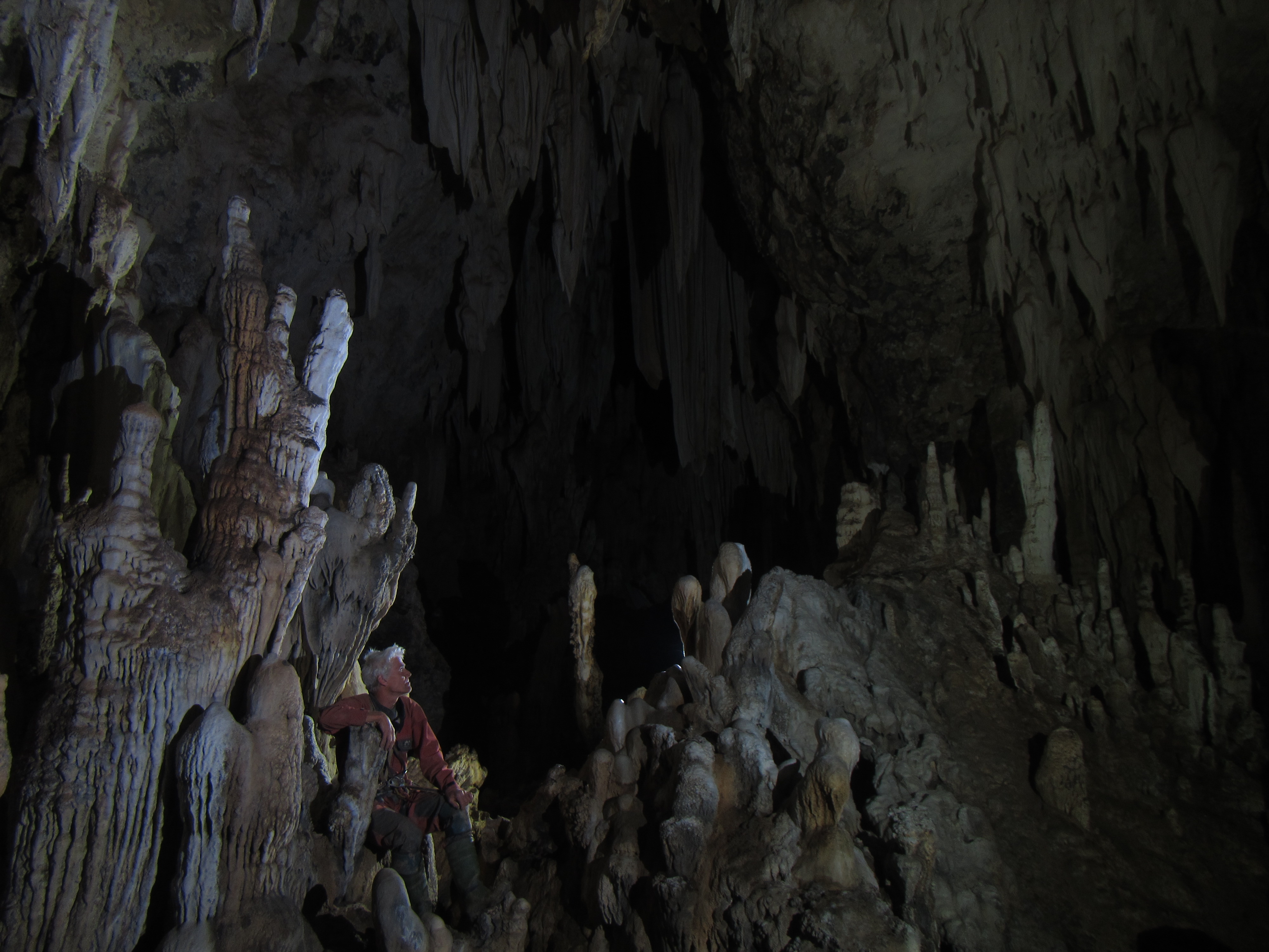
Large fossil cave passage with extension calcite formations in Skylight Hole, Ywangan Township, Southern Shan State. This is fairly typical of much of the cave we have explored in Myanmar. Download: Shan Plateau Expedition 2014 no surveys; spring stone cavev2; DragonCave-no grid; LinweSinkSystem-nogrid
2016: The expedition targeted the western edge of the Shan Plateau. The expedition was initially based in the town of Kyaukse, from where the team commuted to the base of the ridge every day. The aim of this part of the expedition was to investigate possible resurgences along the base of the ridge which may represent water sourced higher up on the Shan Plateau. Two significant resurgences were located, one smaller outflow near Khin Lae village, and one larger outflow near Phoe Inn village. The Phoe Inn resurgence also had an associated cave located nearby from which the subterranean river and other dry fossil passages could be accessed. In total Phoe Inn Cave was explored to over 1.2km in length, including two entrances. The river sumped in both upstream and downstream directions.
During the second part of the trip the expedition was located in Ywangan. Day forays were made into the surrounding areas to search for caves. Initially a number of small caves and blind shafts were identified, including within areas that lie up to 1400m above the Phoe Inn resurgence. Subsequently a major (two river) sink was found at ~780m above sea level on the newly improved road from Ywangan to Padalin Cave. Ju’s Gu was is now the deepest mapped cave in Myanmar, extending to a depth of over 300m (of which 280m was descended by the team). This makes it almost twice as deep as the previous depth record for a mapped Myanmar cave (155-160m). There are three large (30-50m) pitches continuing from the exploration limit of Ju’s Gu, one of which appears to lead into large horizontal development, but they have bad air that prevented further exploration. The termination of the explored cave is ~50m above the base of the escarpment, in an area where villagers report 9 cave entrances some of which are ‘large enough to house an aeroplane’. Download: Shan Plateau Expedition 2015-16
2017: Despite last minute withdrawal of permits to visit normally closed areas in the East of the Shan Plateau the team returned and surveyed around 4km of cave between Ywangan and Pindaya. Full details to follow.
2020: The most recent expedition took place over the Christmas and New Year break of 19/20. After some negotiations, permissions was gained to finally visit the Eastern Shan, where a small team spent 9 days mapping Som Hein cave system. This extensive cave is well known locally for spiritual reasons, but also turned out to be the longest yet mapped in Myanmar at 11.6 km and still ongoing.

The main Buddha in Som Hein Cave, Eastern Shan
